
Our Products
We offer to the petroleum-exploration industry a broad range of geochemical and modeling products.
Multi-Client Studies
Please click on the appropriate box(es) below for information about any or all of these studies, which are available for purchase and immediate delivery. Please contact us for further information.
Obvious advantages of participating in multiclient studies are reduced cost and access to data that would otherwise be unavailable.
Three Forks Stain Study
This study, which focused on the origin and movement of oils in the Three Forks, was successful in spite of the scarcity of significant stains within the Three Forks. The key to our success was oversampling and screening to select the best stain samples. An accurate appraisal of maturity of extracts from both source rocks and stains was achieved using some new interpretational techniques. Of particular value was our development and use of a “basket” of several molecular maturity indicators, which helped improve the signal-to-noise ratio.
We produced a map of relative maturity in the Bakken source rock across the entire study area. In general, Bakken maturity correlates well with present-day burial depth, but some anomalies exist. These anomalies show that present-day burial depth is an imperfect proxy for thermal maturity; other factors, such as variations in regional heat flow, thermal events related to volcanism or convective events, structural lineaments, and differential amounts of uplift and erosion probably play a role.
Comparison of maturities of migrated and unmigrated fluids allowed us to determine with confidence the maturity range for the main generation and expulsion windows in both the Bakken and Three Forks.
Stains from the Three Forks were partly correlated with Bakken source rocks, but other organofacies also appear to have contributed. Various possible explanations are considered. Migration pathways are discussed in some detail.
Our map of maturity of the Three Forks stains is extremely interesting, and has important implications for possible lateral migration within the Three Forks. Some data suggest a possibly important role for regional fracture networks associated with tectonic lineaments. This idea might lead to new plays both within and beyond the conventional play limits. Unusual characteristics of the Parshall Field are also discussed.
Permian Basin Maturity Modeling Study
The study was carried out by Sirius Exploration Geochemistry using our proprietary Novva software, which provides a new and unique tool not only for 1-D maturity modeling, but also for geologic investigation and integration. The study includes 103 wells spread across the greater Permian Basin. The great majority of those wells penetrate into or through the Ordovician Ellenburger Group, and all models constructed will cover the entire stratigraphic section from the Ellenburger to the surface.

Map of the study area showing the locations of the 103 modeled wells.
The benefits and deliverables for this study include the following:
- Carefully constructed geohistory curves for all models, with superimposed tectonic events and tectonic-subsidence curves.
- Maps of a variety of input and output data. An example of mapped input data is basal heat flow. In addition, Ro and Transformation Ratio are mapped for each modeled source-rock interval, which range in age from Devonian through Permian.
- Time plots showing cumulative oil and gas generated and expelled through time for each suggested source interval in each modeled well.
- Plots showing the anticipated in-situ hydrocarbon mixtures (e.g., GOR) for each suggested source-rock interval and all proposed reservoirs in each modeled well.
- Maps of anticipated hydrocarbon composition within each unconventional reservoir across the study area. Those maps are influenced both by the mixture that is generated directly from kerogen, and any cracking of oil to gas that may have occurred.
- Full documentation of all details of the model-building and optimization processes, including comprehensive discussion of our reconstruction of the tectonic, erosional, and thermal history of the study area. All assumptions are clearly identified and justified.
- Comprehensive written report in electronic form, with appendices showing output data for all models.
- All input data for models in Excel format and as Novva files.

Geohistory plot for a modeled well in the Delaware Basin, showing proposed tectonic events and tectonic subsidence (red line).

Colored contour work map of present-day basal heat flow across the greater Permian Basin.

Cumulative hydrocarbons generated and expelled through time at the base of the Woodford at a modeled location in the Val Verde Basin, showing timing of generation and expulsion for each product. Also shown in blue is the rate of oil generation through time.
Because of the care we take in building and calibrating our models, and because of our ability to choose the most-appropriate kinetics for each source rock, our calculated levels of hydrocarbon generation and cracking have a high level of confidence. Consequently, our maps of generation are the most-accurate available, and are directly applicable and essential for making a variety of exploration decisions, such as entry or exit from specific plays, risking and prioritizing of resources, and expansion or contraction of acreage positions. We do not use calculated or measured Ro or Ro equivalents as a proxy for generation and cracking, but rather employ those data to calibrate our proposed burial and thermal histories. We calculate generation and cracking directly using kinetic equations and source-rock kinetics derived for this study.

Present-day calculated Ro profile at a modeled location in the Midland Basin, with stratal boundaries shown in gray for reference. Green points are Ro equivalents obtained from measured mean activation energy values (Mean Ea) generated for this study.
Less-obvious but also important for making exploration decisions is the improved understanding of the integrated geologic history that can be obtained from careful and thoughtful 1-D modeling studies. This study includes a comprehensive review of the tectonic histories of the different parts of the study area, including detailed analysis of the significance of the tectonic-subsidence curves. It will aid in understanding the causes and consequences of events during unconformities, and the links among water depth, elevation, tectonic events, lithologies, eustasy, and isostasy through time. This information can then be linked to deposition of source-rock and reservoir facies, and to thermal history.
Anadarko Basin Maturity Modeling Study
This multiclient study has reconstructed the depositional, tectonic, erosional, and thermal history of the Anadarko Basin. It includes models for 80 wells distributed evenly across the basin. Particular attention was paid to creating fully integrated geologic models from the Cambrian to present day. Models were calibrated using log porosities, corrected wireline log temperatures, and thermal indicators, mainly Mean Ea and Ro. Hydrocarbon-generation history was calculated for eight different source rocks, and the potential for preserving hydrocarbons against cracking was examined in reservoirs of all ages.
This study provides important new insights that will lead to reassessment of the thermal history and maturity levels for all source rocks in the basin. It is thus an essential source of information for any company that wants to explore conventional or unconventional plays in the Anadarko Basin using the most-modern ideas and technologies.
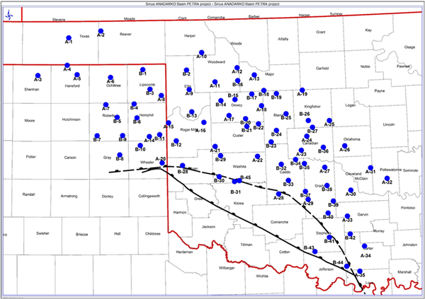
Figure 1. Map of the Anadarko Basin, showing the locations of the 80 wells used in this study.
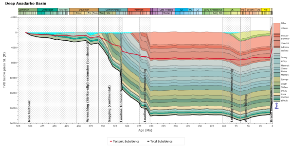
Figure 2. Geohistory plot for a deep well in the Anadarko Basin, showing proposed tectonic events and tectonic subsidence (red line). Plot was created using our Novva software.

Figure 3. Structure map on the top of the Woodford, one of the multiple source horizons to be modeled in this study.
Powder River Basin Maturity Modeling Study
This multiclient study reconstructs the depositional, tectonic, and thermal history of the Powder River Basin. The study includes 75 wells distributed isotropically across the basin. Careful attention was paid to creating a fully integrated geologic model from the Cambrian to present day. Models were calibrated using log porosities, corrected wireline log temperatures, and a variety of thermal indicators. Hydrocarbon generation history was calculated for ten different proposed source rocks, and the potential for preserving hydrocarbons against cracking was examined in reservoirs of all ages.
This study is available for sale to the public. We anticipate that it will become the gold standard for assessing the thermal history and maturity levels in the Powder, and thus will be an essential source of information for any company that wants to explore scientifically in the Powder River Basin.

Figure 1. Map of the Powder River Basin showing the locations of the 75 wells used in this study.
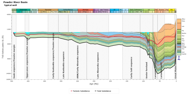
Figure 2. Geohistory plot for a typical well in the Powder River Basin, showing proposed tectonic events and tectonic subsidence (red line). Plot was created using our Novva software.

Figure 3. Present-day calculated Ro profile and measured Ro values at a modeled location in the deep part of the Powder River Basin. Plot was created using our Novva software.

SiriusXGC: Multi-Client Studies
If you are interested in having us consider creating a multiclient study in a particular area, domestic or international, please contact us to discuss the possibilities.